I have totally saved your asses, people who read this blog and are planning to travel by wind-powered boat to the Southern Hemisphere. I am going to give you a handy navigational tip!
Apparently, there is no north star in the Southern Hemisphere! No North Star whatsoever! You can’t use the North Star to navigate in the Southern Hemisphere. So if you’re traveling to the Southern Hemisphere, and you were planning on depending on the North Star for navigational purposes, you would have been SHIT OUT OF LUCK. Because when you cross the equator, the North Star, it completely and totally and utterly vanishes, and you can’t see it! And you can’t use it to find North!
Okay, so let me help you out. If you’re in the Southern Hemisphere, and you’re having navigational issues, just search for the Southern Cross! Not the North Star but the Southern Cross. It is a very teensy little constellation, but if you follow the line created by the two stars (I know that a cross requires four stars, so try very hard to pick the two correct ones), they will take you right to the South Pole. Or, y’know, close enough.
See? I have SAVED YOU.
More saving information: If you get into a fight with an alligator or a crocodile, hit it on the nose, poke it in the eyes, and scream a lot. If that doesn’t work, play dead.
Even more saving information: Garlic fends off vampires and also like demons and werewolves.
You are so very, very welcome.
Showing posts with label Navigational Aids. Show all posts
Showing posts with label Navigational Aids. Show all posts
Friday, March 2, 2007
Monday, February 12, 2007
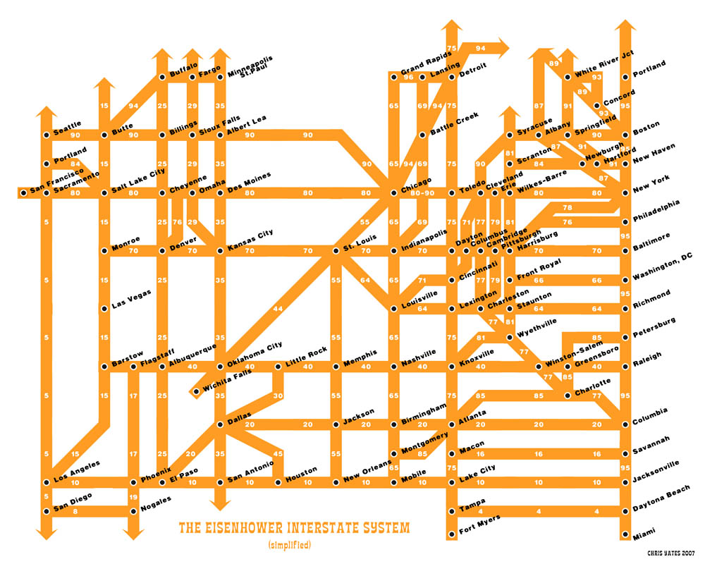
A Tube map of America!
Here is a simplified map of the interstate system.
When I look at this map, my heart leaps, because it appears to be the solution to all of my interstate traveling problems (except the one where I don’t like to merge or switch lanes; that is still an issue). Regular maps bewilder me. There are so many different roads, and everything turns into something else and I can’t tell where one highway goes in a straight line because the map markings, they just don’t make any sense. Whereas this one makes everything so simple. How do I get to New York City? I go straight down I-10 and take a left on I-95, and BAM I am there!
Only at first I couldn’t believe it was that easy. I’ve seen atlases! I know what the road system looks like! And it isn’t this nice grid either! It’s all confusing and weird!
And then I realized that this interstate map is exactly like the Tube map of London: it doesn’t necessarily bear a huge resemblance to the street maps, but it is incredibly useful because you just follow the signs and you will pop up in the exact place where you want to be (or close enough to walk there). Which is why I love the Tube. If I get lost in London, I can just wander around until there appears a Tube station, and as soon as I walk down the stairs into the station, I’m no longer lost! I can get to anywhere then! Now America is like that for me too. All I need to do is find a major city, and I’m good to go.
I’m totally printing a copy of this map and going on a big cross-country road trip when I get home. Anyone want to come? I know where everything is now! We can just go wherever! THE WORLD IS SO SIMPLE NOW!
Subscribe to:
Posts (Atom)